What QNEAT does
QNEAT (QGIS Network Analysis Toolbox) is a QGIS plugin, fully integrated into the QGIS3 Processing Framework, that turns any line vector layer into a routable network and runs three families of network analysis on it: shortest path routing, iso-area (service area / accessibility) generation, and OD-matrix (origin-destination) cost computation. All algorithms share the same underlying QGIS C++ graph engine (QgsGraph, QgsGraphAnalyzer), so they behave consistently across all algorithms and move the computational load of finding optimal paths in a graph to C++. All algorithms in QGIS use the same optimization criteria, have the same direction and speed handling, and treat points that are not on the graph the same way.
Entry and Exit cost handling
Real-world points of interest — a shop, an address, a hospital entrance — almost never sit exactly on a network edge. Every QNEAT algorithm accounts for this by snapping each input point to its nearest position on the network and calculating a separate entry cost (getting from the point onto the network) and exit cost (getting off the network to the destination point), in addition to the cost of travelling along the network itself. Entry cost and exit cost will always be represented in distance or time values, depending on which optimization strategy was used to run the analysis (Shortest path for distance, Fastest path for time). This is what makes a QNEAT shortest path geometry include a short "off-network" leg at both ends rather than starting and ending abruptly at the nearest vertex. Therefore iso-areas and OD-matrices correctly reflect the effort of actually reaching a point rather than just reaching the network near it.
As of version 4.0, entry and exit cost values (both distance and time) are always calculated based on ellipsoidal measurements, using the network layer's own CRS ellipsoid — the legacy "planar" mode to configure has been dropped in favor of this more accurate representation of distance.
Cost units
The unit of every cost value — edge cost, entry cost, exit cost and totals alike — follows directly from the optimization strategy: choosing Shortest path always gives you costs in meters, while choosing Fastest path always gives you costs in seconds, no matter what coordinate system or map units the network layer uses. This is due to the pure ellipsoidal calculation of distances - previous planar calculation methods have been deprecated. Time costs are derived from the ellipsoidal distance of the network edges together with the speed the user provides, so the speed field and the default speed must always be entered in kilometers per hour for the resulting seconds to correspond to actual travel time — entering speeds in another unit (e.g. miles per hour) won't produce an error, but the seconds reported will no longer reflect time based on the ellipsoidal distance calculation. For this reason, a default speed greater than 0 km/h is always required whenever a time-based strategy is selected. Missing or negative speed values in the speed field default to the default speed.
Euclidean distance vs. TIN interpolation for isochrones
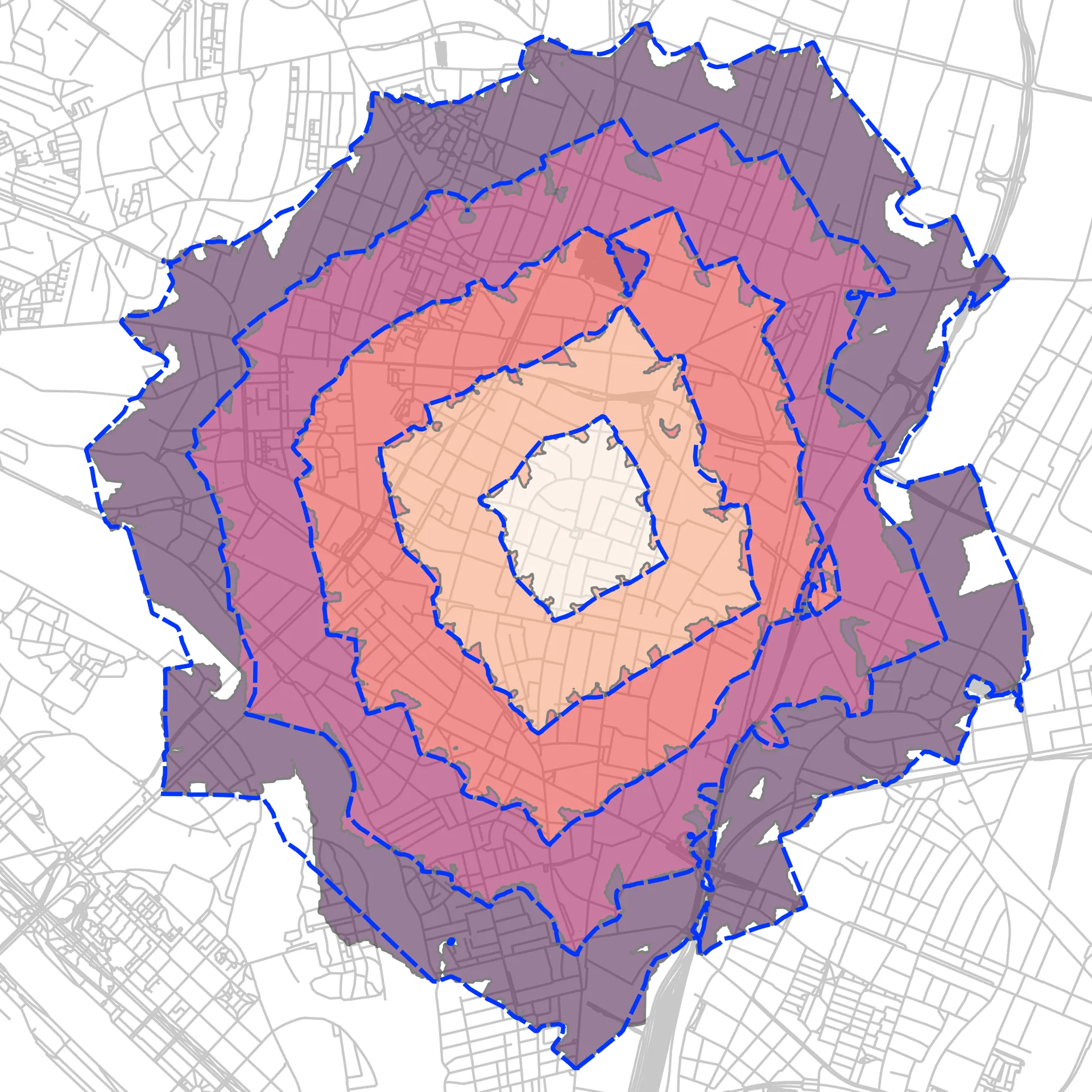 Data Source: Stadt Wien – data.wien.gv.at
In QNEAT version 4.0 a new interpolation technique for isochrones has been introduced: Euclidean distance interpolation. Using Euclidean distance interpolation, isochrones are computed exactly (depending on the interpolation resolution) instead of applying a TIN approximation. The Euclidean distance algorithm propagates the accumulated cost values on the network into an off-network raster grid, computing exact straight-line distances from the point where the shortest path leaves the edge out to the maximum distance specified by the user, or the outer border of the isochrone. The picture on the side shows the difference in exactness between both interpolation methods: The euclidean distance isochrone is colored, the TIN isochrone is show in a blue outline.
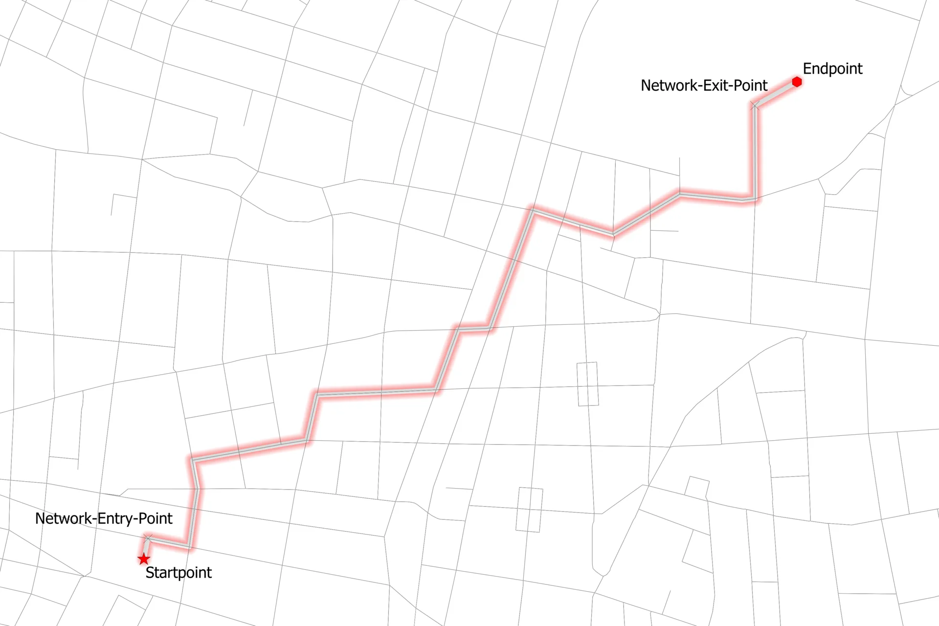 Data Source: Stadt Wien – data.wien.gv.at
Shortest Path
Solves the classic routing problem: the cheapest path between an origin and a destination point on the network, using Dijkstra's algorithm. Available as a single algorithm, Shortest path (point to point).
Features
- Full path geometry, including the entry and exit legs described above
- Cost breakdown in the output attributes: entry cost, exit cost, on-network cost and total cost
- Distance or time optimization, with direction- and speed-aware routing
Application areas
- Routing a single trip between two known locations (site visits, deliveries, emergency dispatch)
- Auditing or visualizing why a route takes the cost it does, via the entry/exit/network cost breakdown
- Building block for larger workflows that need one authoritative "how do you get from A to B" answer, distance and time included
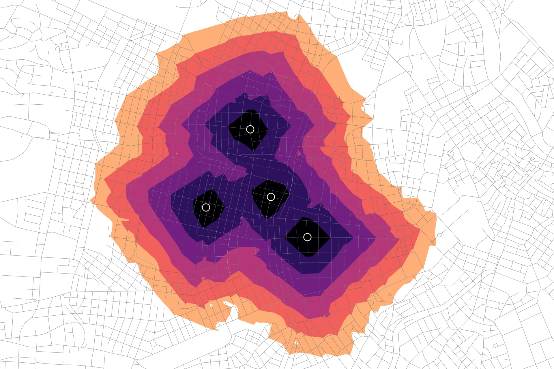 Data Source: Stadt Wien – data.wien.gv.at
Iso-Area
Answers "how far can you get?" from one or many starting points within a cost budget (a distance or a travel time). QNEAT offers three output flavors on the Iso-Area algorithm page, from lightweight to fully finished cartography:
- Pointcloud — every reachable network node as a point, tagged with its cost. Cheapest to compute, useful as raw analysis input.
- Cost surface — a continuous raster of network-distance, interpolated using either the new Euclidean Distance Transform method or TIN interpolation.
- Polygons or contours — ready-to-map service area polygons or cost-break-line contours at a configurable interval, generated from the cost surface via GDAL (no matplotlib required, as of 4.0).
Features
- Single point or point layer as origin(s), each analysis point keeping its own ID in multi-point runs
- Configurable cost interval to control the number and spacing of bands
- Choice of interpolation method and, for the Euclidean method, a maximum off-graph travel cost cap
Application areas
- Accessibility and catchment analysis: what area/population can reach a facility within X minutes?
- Site selection: comparing candidate locations by the area or population they'd cover
- Emergency service coverage: mapping realistic reach for ambulances, fire stations, etc.
- Retail and amenity planning: overlapping service areas to spot gaps or redundancy
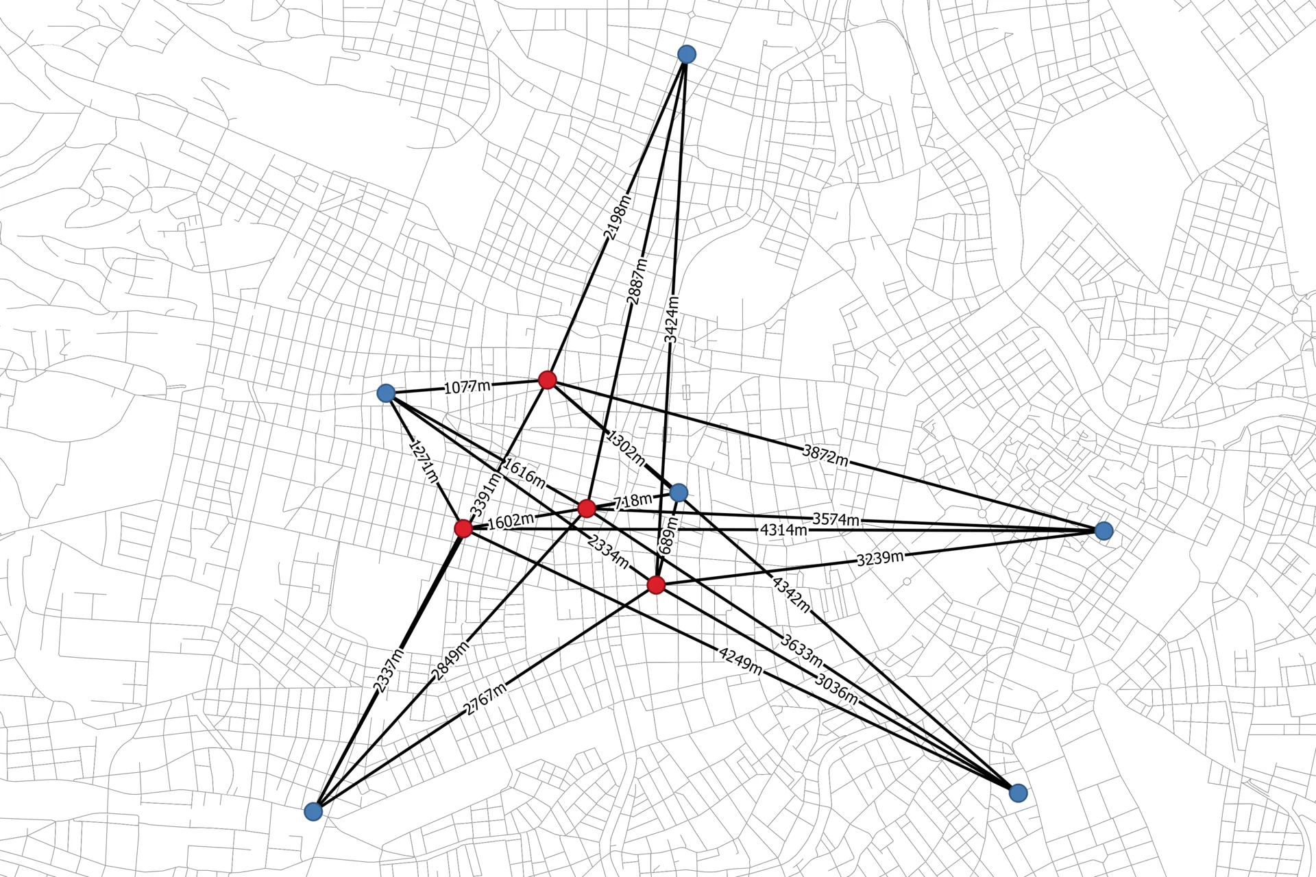 Data Source: Stadt Wien – data.wien.gv.at
OD-Matrix
Computes the network-based cost between every combination of points across one or two layers, without needing full route geometry for each pair — ideal when you need costs at scale rather than individual paths. Four algorithms on the OD-Matrix algorithm page cover m:n (between two layers) and n:n (within one layer) relations, each as lines/routes or as a plain table.
Features
- m:n (origin layer × destination layer) and n:n (all pairs within one layer) modes
- Line output as either straight connectors or actual routed paths ("Line"/"Route" matrix output type)
- Table output with no geometry, ready to save directly as
.csv - Full cost breakdown per pair: entry cost, network cost, exit cost, total cost
Application areas
- Transportation planning: travel time/distance matrices between zones or facilities
- Accessibility studies at scale: comparing many origins against many destinations at once
- Spatial interaction and gravity models, which consume OD cost matrices as direct input
- Logistics network analysis: cost between depots and delivery points without computing every route geometry
This page covers current QNEAT (4.0+) only. If you're comparing against the previous release, see Changes from QNEAT3 or the archived QNEAT3 page.